Plot airport location with Openlayers WKT / VUE / Azure SWA / X-plane DB.
Implemented API with simple Openstreetmap UI.
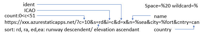
See it work https://yellow-ocean-0e3b06300.3.azurestaticapps.net
hm-dv3 / eta Goto Github PK
View Code? Open in Web Editor NEWThis project forked from humian1974/eta
Plot airport location on Openstreetmap. Airport database is based on x-plane 11.
Home Page: https://yellow-ocean-0e3b06300.3.azurestaticapps.net/