This repository is archived and no longer managed.
Please vist the ArcGIS Explorer help documentation for more information on linking to Explorer
This is a multi-language repository that contains documentation and sample code for creating custom URL schemes in Explorer for ArcGIS.
- iOS: Explorer for ArcGIS 18.1.0 or later
- Android: Explorer for ArcGIS 18.1.0 or later with limited support
- Documentation on the URL scheme structure
- Sample code for Python
Read the following documentation and clone down the appropriate language into your development environment.
A URL scheme allows you to launch a native app from another app, website, or email. You can set options in the URL that will be passed to the app you want to open, causing it to perform specific functions, such as opening a map to a specific location and scale. This capability is available on Explorer for ArcGIS for iOS and Android.
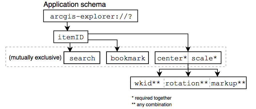
All Explorer URL schemes start with the application scheme of
arcgis-explorer://and can contain additional query parameters in the following format:
arcgis-explorer://?parameter=value¶meter=valueThe following diagram is meant to be used as a quick reference to show how the parameters can be used together. The rest of this topic describes each parameter in greater detail.
This is one of the simplest parameters that can be used. Explorer searches for the item (in ArcGIS Online or Portal) and attempts to open the map using the map’s default center and scale. If the user is not signed in, Explorer will continue without signing in and search ArcGIS for the item.
itemID: Sets Item ID for the map. The item referenced can be of type Web Map or Mobile Map Package that is shared with the current user. Mobile Map Packages will be automatically downloaded if not already on-device. If the item referenced is shared publically in ArcGIS Online, the user tapping on the URL scheme does not need to be signed in to Explorer in order to access the map.The following examples show how you can open a specific map from a URL.
// open a public Web Map
arcgis-explorer://?itemID=0c900ae2a1084d27b608233921ef1a84

// open a public Mobile Map Package
arcgis-explorer://?itemID=6ca5f9cfea0c47b2969ee9750693301f
NOTE: All other parameters require that a item id be specified.
In addition to opening a map to the default center and scale, there are a couple ways to set the map extent in order to provide a custom map viewing experience. You can specify the
centerandscale(optionally providingwkid,rotation, and/ormarkupparameters) or specify abookmarkfrom the map . Alternatively, you cansearchwithin the map to let Explorer determine how the initial extent should be set while also displaying the matching results.
centerandscaleare used in conjuction to recenter a map. Thecenterparameter can include either a set of latitude and longitude coordinates (decimal degrees), a query formatted address, or a feature search result. When specifying acenter, thescalemust also be provided.
center: Centers the map to a certain location. Provide center in the following formats:
- Comma-seperated latitude/longitude (y/x) pair in WGS84 (WKID:4326)
- Address (plus-encode spaces) to be reverse geocoded by organization geocoder (Mobile Map Package's with locators will not utilize geocoder)
- Feature search result (plus-encode spaces). Explorer will automatically center on top result.
scale: Sets the scale in map units that the map should be rendered.The following examples show how you can use
centerandscaleto adjust the map view point from a URL.// center on a coordinate pair arcgis-explorer://?itemID=0c900ae2a1084d27b608233921ef1a84¢er=41.780618,-88.179449&scale=3000 // center on a reverse geocoded address arcgis-explorer://?itemID=0c900ae2a1084d27b608233921ef1a84¢er=899+Aurora+Ave,+Naperville,+Illinois&scale=1000 // center on a feature from map. In this case, Hydrant #43141 arcgis-explorer://?itemID=0c900ae2a1084d27b608233921ef1a84¢er=43141&scale=500In addition to providing a
centerandscale, you can optionally specify any combination of thewkid,rotation, ormarkupparameters. Note, when using any of these parameters, anitemIDandcenter/scaleare required.
wkid: Specify coordinates in a different spatial reference. Defaults to WKID: 4326 (WGS84) if parameter is not used.rotation: Rotate the given map 0-360 degrees. Sets the rotation in degrees that the map should be rendered. Acceptable values range from 0 - 360.markup: Enable markup mode when opening a map.The following examples show how the
wkid,rotation, andmarkupparameters can be used together from a URL.// rotate the map 180 degrees arcgis-explorer://?itemID=0c900ae2a1084d27b608233921ef1a84¢er=41.780618,-88.179449&scale=1000&rotation=180 // center on coordinates in NAD83 / UTM zone 19N (WKID: 26919) spatial reference arcgis-explorer://?itemID=0c900ae2a1084d27b608233921ef1a84¢er=4807094.8078305572,-1096767.7053304175&scale=1000&wkid=26919 // rotate the map 180 degrees and enable markup mode arcgis-explorer://?itemID=0c900ae2a1084d27b608233921ef1a84¢er=41.780618,-88.179449&scale=1000&rotation=180&markup=trueInstead of providing a center and scale, the
bookmarkparameter can be used to open the map to a specific viewpoint by specifying a bookmark from the map. When providing a bookmark, you must also provide anitemIDfor the map. You cannot provide any additional parameters.
bookmark: Adjusts map viewpoint to the specified bookmark from the map. Bookmark name should be plus-encoded for spaces.The following example shows how to open a map to a specific bookmark within the map from a URL.
// open map to a bookmark named "Centennial Park" arcgis-explorer://?itemID=0c900ae2a1084d27b608233921ef1a84&bookmark=Centennial+ParkThe
searchparameter allows you to quickly launch a map and execute a search, returning places and feature results without having to manually type your query using the search tool.
search: Executes a search, returning places and/or features. Query string should be plus-encoded for spaces.The following examples show how you can use the search parameter in a URL.
// search for an address from the geocoder
arcgis-explorer://?itemID=15c3a41bc01e4f8b9922736f3c194c29&search=899+Aurora+Ave,+Naperville,+Illinois

// search for a POI from the geocoder
arcgis-explorer://?itemID=15c3a41bc01e4f8b9922736f3c194c29&search=Gas+Station

// search for a feature from map. In this case, Hydrant #43141
arcgis-explorer://?itemID=0c900ae2a1084d27b608233921ef1a84&search=43141
- Support on the Android version of Explorer for ArcGIS is limited to
itemID,center/scale, androtationparameters. Center parameter cannot reference feature from layer configured for search.If an error is encountered when processing a URL scheme, the user will receive an alert.
Not Esri's doc but still pretty dang useful :-)
Find a bug or want to request a new feature? Please let us know by submitting an issue. Thank you!
Anyone and everyone is welcome to contribute. See our guidelines for contributing.
Copyright 2016 Esri
Licensed under the Apache License, Version 2.0 (the "License"); you may not use this file except in compliance with the License. You may obtain a copy of the License at
http://www.apache.org/licenses/LICENSE-2.0
Unless required by applicable law or agreed to in writing, software distributed under the License is distributed on an "AS IS" BASIS, WITHOUT WARRANTIES OR CONDITIONS OF ANY KIND, either express or implied. See the License for the specific language governing permissions and limitations under the License.
[](Esri Tags: iOS, Android, Explorer, URL Scheme) [](Esri Language: Java, Swift, Javascript)